Little hill, big history
It has been some time since I have tread on Bredon hill, one that has fascinated me since I first ran its many permeations and contours some 5 years ago.
At the time I did write a blog about this hill but have some how lost it, but with my 42nd birthday now edging closer one of my birthday wishes was to head back to this hill for another visit and a better investigation of its many myths and stories.
Bredon hill starts as it means to go on, as an oddity of places the name Bredon itself literally translates as hill, hill, hill in not one but three different languages. A mix of rough Celtic and Britonic with a few bits of Saxon and Norman thrown in for good measure.
Bredon is now distant outlier to the Cotswold hills but before the advent of geological upheaval and erosion it would of formed a long range, uniquely you have to think of the hill as an upside down cake, the surface being composed of oolite limestone, capped off with chalk and underneath being mainly clay, which present an interesting mix as the clay retains water which is great above as the water will drain away easily, but underneath due to the clay it cannot go any further and so creates a hill that isn’t stable.
Around the 1700s a cave was reported to be on the Northern edge of the hill below Kemerton camp but by the end of the 1700s it had vanished from mention and it is thought that the landslip completely collapsed the cave and was forever lost. During the slip, it was noted a large amount of grain was found, this was common practice during the iron age where grain would be buried and sealed from the outside in a means to preserve the precious food source.
Bredon Hill is one of those rare sites which have seen an almost constant human present, from the earliest of humans in the Paleolithic where hand axes and other stone tools were found, zip forward to the Iron age where we have not one but 3 iron age camps atop the hill, the Romans making an appearance in the flat ground ground below the hill, through to the Saxon period and Norman periods of history.
But today we start our little wander starts from the charming sleepy village of Elmley Castle which takes its name from the 11th Century fortress which sits above the town. With its black wooden framed houses, thatched roofs and old Cotswold stone exudes every bit the archetypal English village.


We parked just outside of the main town streets in a little picnic area and set off back towards the amazing church we had seen not long ago, St Mary’s which also dates from around the 11th Century, around the church exterior and interior there is a number of herringbone stone work giving a clue to its original builders, as you approach you get your first glimpse of a time gone by, a 16th Century sun dial dotted with 20 dials of varying shapes and sizes now quite eroded and no numerals are to be seen.


We headed in through the front wooden door and were met with a rather interesting sites, immediately to the left of the entrance is a rather ornate tomb, the Savage Chapel is a memorial to three members of the savage family and a first for us, one is holding a baby which was born after the father death.
In front of this memorial and looking rather relaxed reclining back and staring into the distance is the 1st earl of Coventry, why is the early of Coventry here here, well a dispute with father and son saw the son refuse to allow him to be interned at the family chapel.


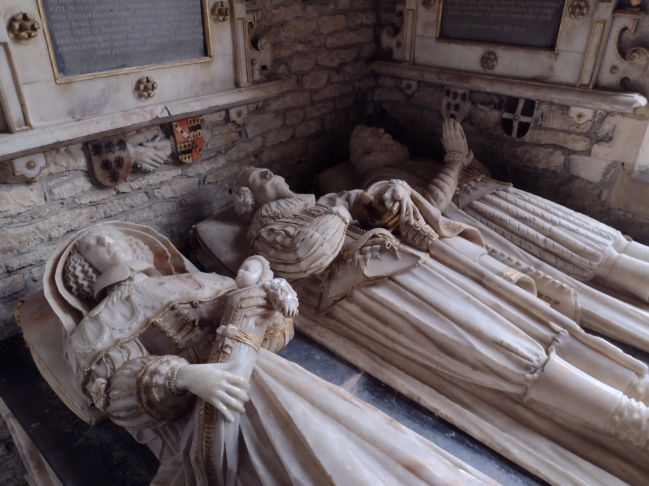


Sitting in between these 2 wonderous memorials is a 14th Century stone coffin slab with a ornate cross carved into its top, who it belongs to and where it came from is a bit of a mystery for now.
There a number of interesting features around the church its self including the ornate stone font, dating from the 13th Century it is the oldest surviving furnishing inside the building. We headed out and as I pulled back the large wooden door in the porch area a carved stone rabbit popped out along with a few other carvings on the walls which are described as being Norman in origin.
We headed out and around the left of the building cutting across filed and then a slow climbed up towards fiddlers knap and the Elmley Castle on our right. I would of loved to have walked up on to the ruins of the castle but it appears the land here is privately owned, I have to say I was a little annoyed at this, the land itself served no use to a farmer given its topography and historic importance and so you have to look at it from a distance. Now nothing more than banks and ditches with some stone work visible, it was first constructed in the 11th Century and built by Robert_Despenser before passing to his brother after his death. Like most castles it eventually fell into disrepair before stone was quarried from it and used to build and repair Pershore bridge.


We walked up through Long Plantation and took a seat at the top here which afforded us views down onto Teweksbury and far beyond, a quick water stop and we set off again, following the meandering path towards the goal for today of the hill fort.

We soon began to enter the first of 2 bank and ditches of the outer fort, with Parsons folly popping its head above the mounds on occasions, we wandered across what would of been the main living area of the fort and were afforded some quite astounding views out towards the Malvern hills and British camp, to the Welsh border of the Shropshire hills and its very own hill fort, I imagine that in an extremely clear day, smoke from fires would of been visible to all hill forts of the area.
It is thought that during the 1st Century AD just as the Romans were first invading the country, a battle took place here the result of inter tribal warfare perhaps?, during an archeological dig in the 1930s the bodies of some 50 men and boys were found, all either missing their heads or lower jaw bones along with a number of weapons.


There has been much speculation about this find with common thinking that another tribe attacked the one here and then massacred the 50 people, removing or taking their heads as a trophy, some skulls were found with charring or burning with speculation that they were placed on top of the wooden palisades and then set alight. It was abandoned not long after this.
Another line of recent thinking and research that this could of been the result of a sacrifice, it seem unlikely here though, given the number of bodies and lack of broken weapons which were a common votive offering of the Iron age. I have also read that this could of been the result of a raiding party from across the shores of the English channel. We know it was not the Romans as there have been no Roman finds alongside the bodies.
The Romans seemed to have inhabited the lower slopes of Bredon, with the find of a hoard of some 3,780 coins buried at what was later found to be a Roman villa and with a settlement of both Roman and prehistoric origins being discovered near to Kemerton.
But even with the above discoveries, they are but a starter for what is contained in and around the hill. Not far way there is Conderton Camp yet another ‘hill fort’ and was noted at one time as being named Dane camp. It is thought it may have gained its name from the nearby Deerhurst where in 1016 a treaty was signed by the Anglo Saxon king Ironside and the Danish king Cnut. Cnut has brought his vast army and may have used Bredon Hill and Conderton as a stopping off point.


Conderton predates Kemerton Camp by some years and during the excavations three sheep burials were found below the remains of the circular huts which were thought to be sacrifice ritual of some form.
We took a short wander on the steps of Parsons Folly, a small tower built by John Parsons in the 18th Century to bring the height of the hill to a rounded 1000ft, now used for radio equipment.
It was a welcome rest from the almost constant wind, we dipped off to the right and from the very top of the hill here you can make out what is known as the Elephant stone, due to its shape resembling a seated Elephant. It is also known as the Banbury stone a mass of Oolithic limestone and on closer inspection resembles concrete. Oolithic limestone is basically eroded and then recompacted limestone full of little pot marks and tiny stones.


The stone is of natural origin and thought to have sat atop a cave which once sat underneath the fort with some theorizing that it may itself of been a site of great spiritual importance to those early Prehistoric and iron age folk. It is believed that all the stone here was once a great piece of Oolite but as a landslip occurred it has fallen and broken in two.
Owing to its position there have been the more occult amongst those that believed this was a sacrificial stone used by druids and witches through the ages, but given that its folklore is relatively recent it is likely these tales and stories are of more modern origin with writers of the mysterious copying and extending its tenuous link to something otherworldly.
It offers the walker an outstanding view into flat lands of Worcestershire and beyond, I have read that it also lies on what is known as a lay line and on certain days such as the Solstice the sun rises and sets in line with the stone.
We headed back along the same track heading towards Elmley and cut off down the slope towards Doctors wood and to the left side of Elmley castle to connect with the Hill lane where we wandered past chocolate box cottages resplendent with their thatched roofs, we walked past a rather interesting cottage, one that had a stone around 3ft high sat in front of it. What made it interesting was that the hedge and actual garden had been built around it and it almost resembled a little shrine.
What this stone is still remains a mystery at the time of writing as no one seems to know, one possibility if that of a boundary marker.


There are other more gruesome discoveries on the hill, ancient stones sitting hidden away, but you will need to pop back for my next foray onto the hill and a possible camp out soon.