Kingdoms lost
The man took his final sip of strong wine as he lay back upon the hay bale which had become his bed and resting place for so many years now, the night had been fully of revery, dancing and more than enough drinking.
He closed his eyes and fell into a deep and drunken sleep, but if the stories told are to be true he would never wake again, his body lost the cold dark sea.
Today Borth is a small seaside village on the West coast of Wales providing homes for both permanent residents and the many holiday makers who call Borth their home. It is situated not far from the bustling town of Aberystwyth and makes up the large Cardigan Bay stretching from Bardsey Island and Strumble head.


Beyound its quiet and quaint seaside persona lies a mystery which could stretch back as far as the last Ice age one passed down in the strong oral story telling tradition, a long held folk memory.
Cantre’r Gwaelod is a land lost to time, to foul deeds, carelessness or even an act of god.
There is no specific time frame for the tale to be placed in, but we do have a few characters to base the story upon.
Cantre’r Gwaelod was a mythical land said to have stretched between Ramsey Island and Bardsey Island and is now under the area known as Cardigan bay. its earliest mention is in the Black Book of Camarthen, written around the 1250 by a single scribe and written from tales within his life time and believed to be the earliest form written entirely in Welsh containing poems and tales including one of the mighty and ever so out of reach King Arthur.
There are many versions of this tale but all lead inevitably to the same place, Cantre’r Gwaelod was said to lie on the fertile flood plains in what is now Cardigan bay, its lands so valuable, that one hectare was equal to four for the rest of Wales. The land was ruled over by King Gwyddo and his palace close to what is now Aberystwyth.
The land owing to its low laying place required a complex system of weirs, gates and sea walls, King Gwyddno entrusted the protection of his land to his good friend, Prince Seithennyn and every night he would close the gates to protect the land from flooding.
Now depending on which story you read, it is some times a woman, sometimes a man, sometimes the woman was distracted by a love interest, tricked by another or either had been intoxicated, as in this tale, the kind held and great banquet and the keeper of the gates imbibed a tad to much, he passed out and the stormy sea coupled with the spring high tide flooded the 16 villages behind the walls.
What adds weight to this tale are the small points of evidence that seem to lend some credence to the tale, the Gough Map a mid 14th C map and thought to be the most accurate map of Britain before the 1600s was found, when researchers took a closer look they could see 2 distinct islands or land masses, one between Aberystwyth and Aberdovey and the other between there and Barmouth to the north.

Researchers believe these 2 land masses are perhaps left overs from the previous ice ages and slowly over time eroded by the sea and rivers, its date is still contested but some believe it to be an updated version of something much earlier but all agree that despite its mythological drawings that it is correct.
Along with the map, there are a number of causeways that project from different points along Cardigan bay with one being Sarn Badrig or St Patrick’s causeway and extends for about 20km from the shore and as it is easy to walk upon it more than lends its support for lost lands.
Just out from Borth and at low tide you can wander out and at first spot black blobs protruding from the sand, its not until you get closer that you can in fact see the remains of a forest, some 4,500 years old, submerged and hidden for most of the time, it was after a giant storm in 2014 uncovered the remains of a native forest that once flourished on the fertile plains, in the midst of time the Irish sea was quite shallow with only rivers flowing that could be crossed, but as ice melted and seas rose the rivers widened and became what is now the sea.

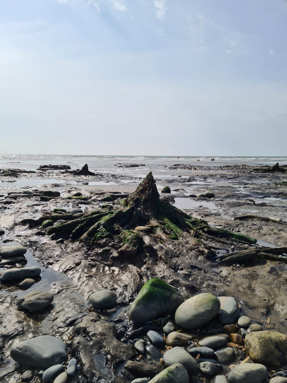
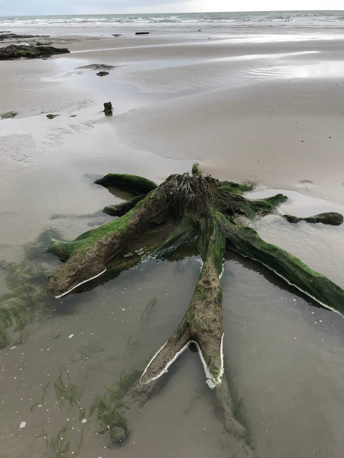
Unfortunately it being winter and in the midst of another storm we were not able to see anything on our trip so I’ve pinched a few images from the web.
Its fair to say that a land mass was once lived on, perhaps farmed and hunted on, people called it home and for a time perhaps flourished. If you familiar with the story of Dogger land then you will be very familiar with the land that once connected the UK to Europe and this land stretched for much of the East coast, that was until a catastrophic land slip originating in the far north of Europe triggered a monumental tsunami that flooded most of the UK and anything on the East coast was wiped from the map, there are also stories held with the oldest surviving stories of The Epic of Gilgamesh which predates the Christian great flood myth.
You may also be surprised to know that there are a further 3 tales of lands lost along the Welsh coast all recount a similar tale of the land suddenly being swallowed or taken by the sea with only a few if any survivors.
We may never know the full truth, but we do know that the sea was once lower than today, perhaps those early humans passed down the story of the great flood and over time it gathered new places and new characters.


